Anastasia Elnikova
(a student of the Faculty of Cryogenic Engineering)
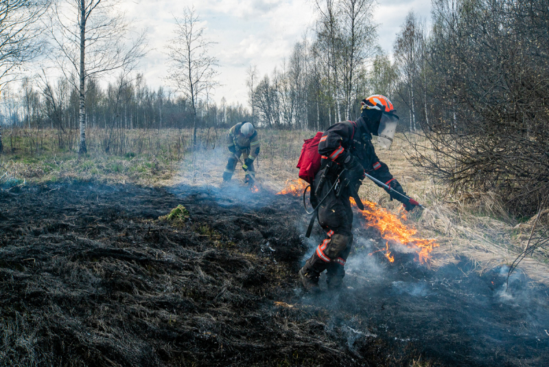
I learned about the Greenpeace project from the #Янекаплявморе (“I’m not just a drop in the sea”) Telegram chat hosted by the eco-activist Daria Chekalskaia. I like this chat because there are lots of internship offers, as well as information about other eco-events and opportunities. I decided to participate in this project when I found out that they are planning to create a neural network in order to predict wildfires and automatically measure their area with the help of satellite imagery. However, first things first it should be done by people.
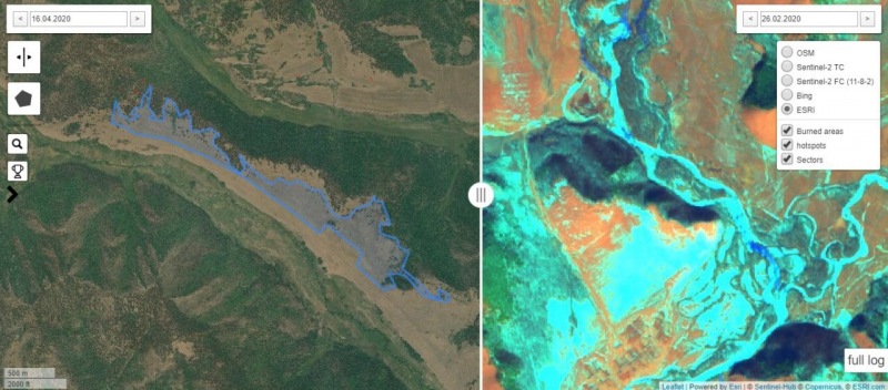
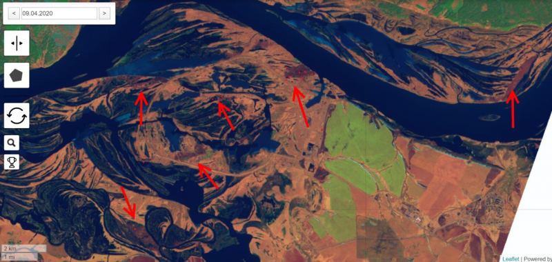
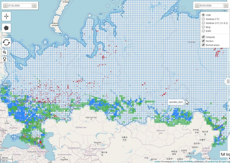
As it turned out, it’s not an easy task. Burnt land can look like floodplains, plowing fields, or cloud shadows. Hotspots, which often indicate fires, could be simply industrial facilities, and moreover aren't helpful in locating small burnt areas. We managed to deal with it thanks to the organizers, who were always ready to answer our questions, and by comparing pictures taken at different times.
Before we began to work on this project, we had been registered, taught how to work in the system, and given 50x50 kilometers of land to process. When we were done with mapping burnt land, a coordinator checked the map, we edited it, and then we moved on to the next piece of land.
I was mapping the Zabaykalsky Krai, however, to my surprise, most of the hotspots were detected in the densely-populated European part of Russia. This means that some wildfires were caused by people, both intentionally and unintentionally. Forest and fields either catch on fire when people burn them to try to get rid of pests and stimulate plant growth, or when a bonfire or a cigarette isn’t properly put out.
For me, like for many other volunteers, mapping was a meditative and relaxing task. I was working on the project in the evening, after a hard day’s work. I can’t say that I personally accomplished a lot, but seeing a hundred people mapping at the same time as you, I realized that even a little bit of effort that comes from many is more efficient than a lot of hard work and self-sacrifice. That’s the approach I find most reasonable for environmental protection: we can succeed only by working on the same goal all together.
This project, undoubtedly, influenced me. Firstly, I changed my opinion on Greenpeace. I had never before participated in their projects and I’ve heard lots of controversial opinions on them. However, the Greenpeace team was very friendly. We had a Zoom meeting with activists and coordinators and it was a very welcoming and supportive environment. It was also a great opportunity to meet like-minded people, despite the remote format. Secondly, I didn’t expect the wildfire areas to be this big. It’s heartbreaking to look at the map and realize that these areas won’t be suitable for plants, animals, and people for many years to come.
For now, the mapping process is completed. The organizers are checking all the data to prepare it for publishing and to eventually create a neural network.
I sincerely hope that the articles will attract a lot of attention from the public, because such data on size and spread of fires will be presented for the first time, and the main thing is – it’s going to be visualized. I think it won’t be possible to ignore the problem thanks to such projects and after widespread news on fires in Siberia, Brazil, and Australia. I believe that people will think about the sequences of their actions more.
Ksenia Belkina
(a student of the Faculty of Software Engineering and Computer Systems)
I found out about this project on Greenpeace’s Instagram page. They were looking for volunteers. It was stated that the season of wildfires began, and if you always wanted to help us, now is the time. The only requirement was to be able to work with a computer. The rest was explained via manuals and video tutorials.
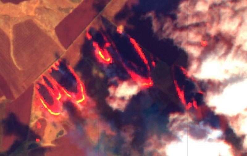
We were comparing satellite images taken in February, March, and May to detect when the first fire hotspots appeared. It was important to do it well and not confuse burnt areas with buildings or fields.
I’ve mapped two sectors: one near Ivangorod and one in the Voronezh Oblast. The first map took about a day, but the second one much longer, because there were a lot of fires.
I had been working on the project for two weeks every day. However, I’m glad I took part in it, as it’s hard to help the environment during self-isolation, when we can’t arrange any events. So, projects like this one allow us to contribute even in these times.
Thanks to this project, I’ve completely changed my mind about Greenpeace. I used to see their work as something removed from reality, like signing this or that petition, whereas for me it should be about real actions. For example, going zero waste, avoiding plastic, and recycling. I think petitions aren’t making enough of an impact, the point is to do something specific right here, right now. This project is one such action.
I was greatly inspired by our coordinators. They helped volunteers, supported us, and answered all the questions. As the head of ITMO University’s eco-club, I want to learn how to do it, too, in order to encourage our ITMO.GREEN team.
One of the goals of this project is to raise awareness. It’s important to understand how accurate the statistical data on fires in Russia is. As we were mapping with great attention to detail, we have the most precise information. The summarizing articles will be published in June. The situation is quite complex, as the amount of fires is really big. While I was mapping one of the areas, I saw that more of it was burnt than untouched. When you see the statistics and visualizations, you realize how terrifying it is.
I hope that people will pay attention to these articles and we will be able to control, scale down, and prevent forest fires when possible.