
Before building a new residential complex or a road, investors and city administration need to assess the resulting economic effects – for example, how the land’s value and profitability will change and what the economic efficiency of the project will be. This task is usually handled by analysts, urban planners, and other experts who manually process a large volume of documents; such an assessment requires substantial amounts of time and money. Digital twins of cities – virtual copies that rely on large datasets to enable city management and help solve everyday problems – can reduce the time needed for data processing and decision making. However, most existing urban digital twins typically focus on visualization and spatial design and either require complex manual interpretation of results or do not take investors’ interests and long-term economic effects for the area into account.
In response to this problem, researchers from ITMO’s Institute of Design and Urban Studies have developed Urbanomy, an AI-based software suite that calculates the economic and social consequences of urban decisions. Based on open spatial, cadastral, and socio-economic data, Urbanomy predicts land values and prepares maps, graphs, and expert evaluation to the standard of an experienced urban planner.
“At first, Urbanomy was a module of the platform Prosto.R where it evaluated projects’ economic efficiency: profitability, pay-off period, return on investment, and other indicators. However, after verifying it on real cases, we saw that the tool solves a broader task: it can evaluate not just the indicators of a specific project, but its effect on land value, infrastructure, adjacent territories, and interests of various participants of urban development. That’s why we started working on Urbanomy as a separate software suite for spatial and economic modelling of urban planning decisions,” says Maxim Natykin, a participant of the project and an engineer at the Research Center “Strong AI in Industry.”

Maksim Natykin. Photo by Vasily Starikov
Unlike many existing solutions that perform separate tasks (visualize data, calculate economic indicators, or help prepare expert recommendations), Urbanomy is capable of completing them all, bringing together spatial analysis, economic evaluation, and decision support. This is important because an urban project can’t be evaluated only economically or on the map; its effect depends on its location, infrastructure, influence on neighboring areas, and the interests of investors, city, and its residents. That’s why Urbanomy can not only predict a project’s efficiency, but also spot possible contradictions between short-term benefits and long-term development of the project.
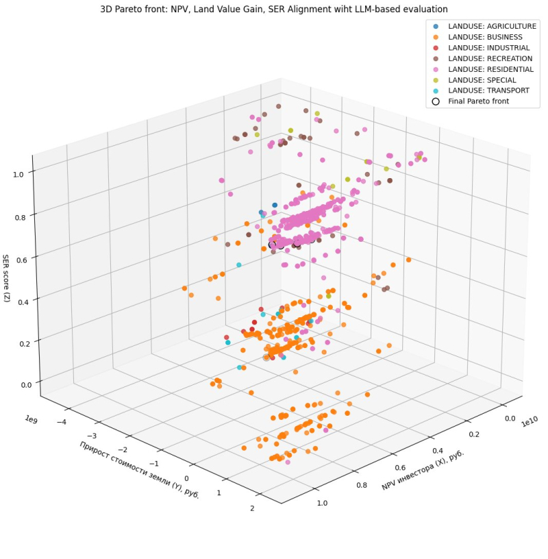
Optimization of a city block’s parameters using AI. Image courtesy of the developers
The program is already capable of predicting changes in the value of a project site and adjacent areas, assessing indirect effects (the impact on residents and investors) from infrastructure changes (road construction, new services, and others), and optimizing development parameters using evolutionary algorithms and large language models.
Currently, Urbanomy is being tested on various urban scenarios, from transport infrastructure to real estate development. For instance, in collaboration with the Institute of Territory Planning “Grad,” ITMO researchers are using Urbanomy to evaluate how new roads can affect the land value and investment attractiveness of city districts. In a separate pilot project with the Scientific Research Institute of Perspective Urban Development, Urbanomy enabled the analysis of an area of the public investment map of Gatchina and helped calculate its development options. This analysis revealed that standard high-density development does produce a quick economic effect, but in the long-term causes infrastructure overload and lowers the quality of urban environment.
“Urbanomy isn’t an AI service; it’s an analytical tool that uses select ML and LLM agent technologies. The project’s aim isn’t to substitute humans but to identify hidden contradictions between a short-term investor benefit and a city’s long-term development. Such conflicts are ubiquitous and it’s best to learn about them before the start of a project, not after. This is made possible with Urbanomy,” adds Sergey Mityagin, the research lead of the project and the head of the Institute of Design and Urban Studies.
Sergey Mityagin. Photo by Dmitry Grigoryev / ITMO NEWS
Urbanomy was developed for municipal administrations, developers, architects, and analysts making urban development decisions. For Urbanomy’s calculations to be considered in urban planning in St. Petersburg and Leningrad Oblast, the service needs to be implemented into the dedicated processes and normative acts. In the future, the system will improve the quality of urban territory development by taking into account not only economic indicators, but also the long-term interests of the urban environment, such as infrastructure load, transport accessibility, the comfort of citizens, the quality of public spaces, and the development of adjacent areas.
In the future, developers are planning to improve the interface, add a chat bot for a no-code option, and develop a plugin that will allow analysts to use the service directly within the QGIS software favored by geoanalysts and urban planning specialists.
Urbanomy’s source code is already available on GitHub.